
Local information from http://www.sfguide.com
ALCATRAZ. Alcatraz is one of our most popular destinations, offering a close-up look at a historic and infamous federal prison, home to the likes of Al Capone, Machine Gun Kelly and the “Birdman.” Visitors to the island can explore the remnants of the prison, as well as learn about the Indian occupation of 1969-1971 and early military fortifications. Ferries to Alcatraz leave from Pier 33, Fisherman’s Wharf. Reservations recommended. Call 415-981-7625 or visit www.alcatrazcruises.com for information and ticket. Now you can buy tickets online and print boarding passes to avoid lines.
ANGEL ISLAND. Angel Island is the largest island in the Bay. Visitors can tour the historic structures that remain from this West Coast internment camp which was the “Ellis Island of the West.” Angel Island offers picnic areas, hiking trails, tram tours, bike rentals and kayaking. Take the ferry from the Ferry Building. Call 415-435-3522 or visit www.angelisland.org.
BARBARY COAST TRAIL. Retrace San Francisco gold rush history by following the Barbary Cost Trail, a self-guided 3.8 mile walking tour marked by a series bronze medallions in the sidewalk, beginning at the Old Mint, 5th & Mission, to Aquatic Park in Fisherman’s Wharf. The Barbary Coast Trail connects 20 historic sites including the birthplace of the Gold Rush, the oldest Asian temple in North America, a Silver King mansion, the western terminus of the Pony Express, six museums, and the country’s largest collection of historic ships. Each end of the walking trail connects to the Powell-Hyde cable car line. Maps are available at San Francisco Convention & Visitors Bureau, 900 Market Street, or at www.sfhistory.org.
BAY BRIDGE. The Oakland Bay Bridge connects San Francisco with Alameda County (Interstate 80) to access cities including Oakland, Berkeley and Sacramento. The Bridge consists of two sections, a western suspension span and an eastern cantilever span. The two spans meet at Yerba Buena Island via a tunnel that gives access to Treasure Island. Treasure Island is an artificial island created in 1939 for the Golden Gate International Exposition of fill dredged from the bay. After the Exposition, plans were to convert it to an airport, but the location proved to windy to be practical. It served as a Navy base during WWII. A number of the old aircraft hangers served as sound stages for film and TV productions. The island has a raised walkway circling the perimeter of most of the island, which is popular for recreation. TI is served by a single Muni bus route, the 108 Treasure Island. Bridge toll of $4 is charged westbound only. www.baybridgeinfo.org.
CABLE CARS. Everyone wants to ride San Francisco's moving landmarks. And they are an exciting trip...up and down some of the city's steepest hills at a steady 9.5 mph. The inventor of the cable car, Andrew Hallidie, came to the US from England in 1852. His father was an inventor who had the first patent in Great Britain for wire rope. Hallidie, working as a surveyor in the gold fields of California, constructed a machine to make wire rope used to pull ore-filled cars up a track from the mines. Soon after moving his wire rope-making plant to San Francisco in 1869, he was horrified to watch a heavily loaded horse drawn streetcar slip and slide down a steep grade, dragging the horse to its death. He immediately turned his attention to inventing a cable grip to pull streetcars safely up and down the steep San Francisco hills. When the world’s first Cable Car traveled down Clay Street on Nob Hill in the summer of 1873, the invention was an immediate hit. Not only was this new system safer, but it opened up many new areas for home building previously thought unsuitable due to their steep hillside locations.
Prior to 1906, the system had 600 cars rolling over its 110 miles of track. The Great Quake, however, caused extensive damage and many cable car lines were never rebuilt. Currently, there are 39 cars operating over a 10-mile network: The POWELL-HYDE LINE runs from Powell and Market over Nob and Russian Hills to Hyde Street Pier in Fisherman’s Wharf. The POWELL-MASON LINE begins at Powell & Market, runs over Nob Hill to Bay Street in Fisherman’s Wharf. The CALIFORNIA LINE runs from the foot of California at the Hyatt Regency, in the Financial District, through Chinatown, over Nob Hill to Van Ness Avenue. Purchase tickets at booths at turntables or pay the conductor on board. Fare is $5 per rider, with no transfers.
The Cable Car Powerhouse & Museum, 1201 Mason Street at Washington, is the working center of the cable-car system. The onsite museum features displays telling the history of the system. The gift shop offers a variety of souvenirs. The Powerhouse is open free to the public daily 10am-6pm. Powell-Hyde and Powell-Mason lines stop at the museum. On the California line get off at Mason Street and walk blocks north. For information, visit http://www.cablecarmuseum.org.
For more transit information, go to http://www.sfmta.com/cms/mrider/visitors.htm.
THE CASTRO. This historic section of Upper Market Street, marked with rainbow flags, is recognized as the center of San Francisco’s gay and lesbian community, but is welcoming to all residents and visitors. Castro Street is lined with specialty stores interspersed with colorful Victorians, restaurants, and pubs. Harvey Milk Plaza, at Market & Castro, is named after San Francisco’s first openly gay supervisor. The Castro Theater, 429 Castro Street, is a great old movie palace that screens classic and art films.
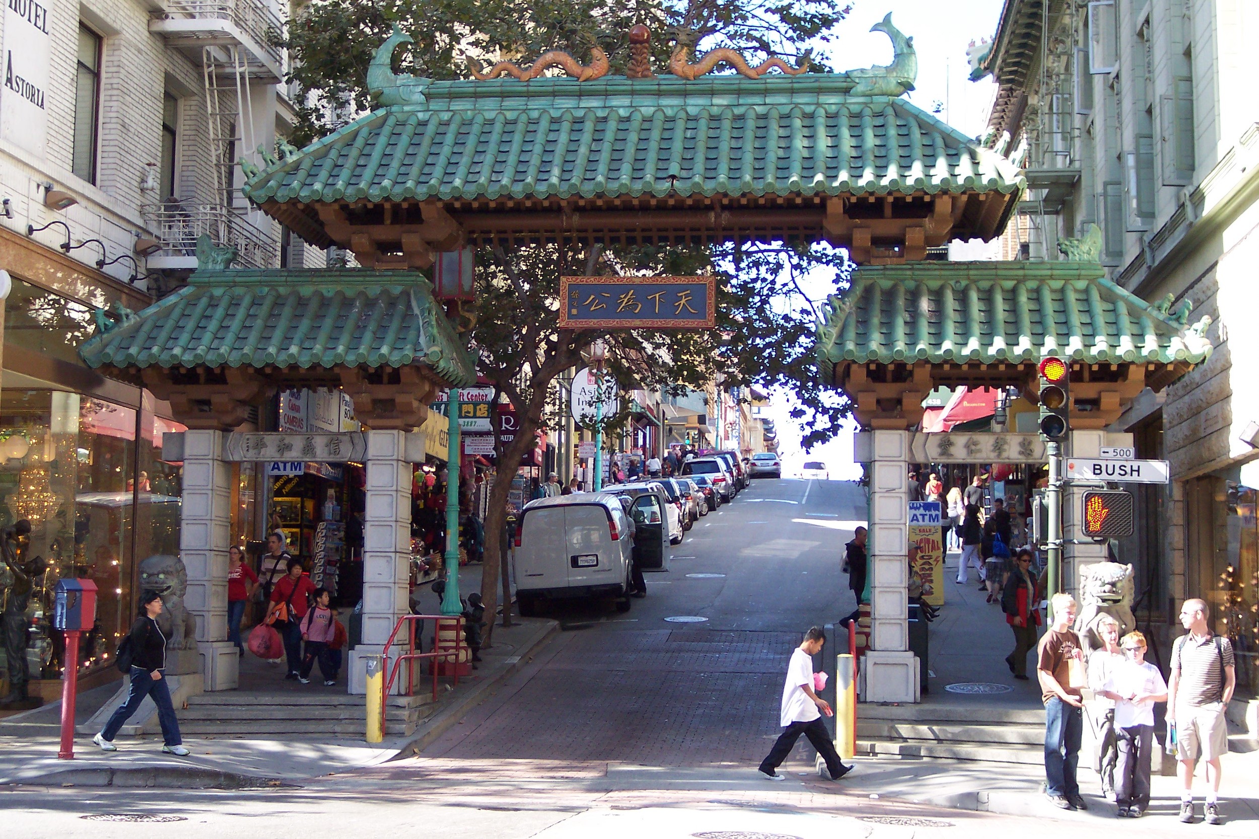
CHINATOWN. Enter Chinatown at Bush and Grant Streets, through the imposing Dragon Gate,a gift to San Francisco from the Republic of China in 1969. The characters above the gate proclaim, EVERYTHING IN THE WORLD IN JUST PROPORTIONS. Home to one of North America¹s largest Chinese communities, Chinatown is a bustling 18 square blocks centered along Grant and Stockton from Bush to Columbus. The streets are lined with food markets, herb shops, temples, restaurants, and stores offering a variety of colorful merchandise. It's easy to give in to the urge to just shuffle down Grant Avenue, buy a few souvenirs or t-shirts and miss the real San Francisco Chinatown. Grant Avenue is the more tourist-oriented street in Chinatown, particularly on the end nearest Union Square and the Chinatown Gate. The Chinatown you see today was built after San Francisco's 1906 earthquake and its architecture is an odd mix of Edwardian fundamentals and Chinese details. Beyond the gate you will see the Dragon Lights, the ornate street lights that were added in 1925 as Chinatown began to be a serious tourist attraction. Landmarks include St. Mary's Church, at Grant & California. St. Mary's Church blends Chinese heritage with the Gold Rush. The granite foundation came from China and the bricks were brought with gold seekers. Portsmouth Square, at Kearny & Washington Streets, made history in 1848 when Sam Brannan announced there he¹d found gold at Sutter¹s Mill. Down the street is Portsmouth Square, on Kearny Street between Clay and Washington (one block down Clay off Grant). where local family gather, old men play elephant chess, and women watch children play. Ten Ren Tea Shop, 949 Grant Avenue, provides a daunting task to picking a Chinese tea - there are so many kinds and different brands and grades one can become intimidated by the choices. Ten Ren offers samples and sometimes suggestions if it isn't too busy. Stockton Street is home to many Chinese markets and stores. Don't be intimidated by the crowds of shoppers that are usually gathered around the shops, inspecting and selecting the fruits, vegetable, and other items piled up on display. Stroll in, wander around, and enjoy the exotic sights, sounds, and scents. Between Grant and Stockton, off the major cross streets, are the Chinatown alleys. Don't miss them, they are the essence of Chinatown. Chinese lore says evil travels in straight lines. Maybe that's why there are so many alleys and small cross streets in Chinatown. The most interesting are Waverly Place and Ross Alley, both parallel to Grant, between Grant and Stockton. Waverly Place has been called the street of the painted balconies. It runs between Sacramento and Washington. It offers excellent photo opportunities. Amy Tan's fans may remember the name Waverly from "Joy Luck Club," and Dashiell Hammett's "Dead Yellow Women" is set in Waverly Place. Ross Alley runs between Washington and Jackson. Ross Alley has been the backdrop for a number of major movies including Indiana Jones and the Temple of Doom, Karate Kid II, and Big Trouble in Little China. The Golden Gate Fortune Cookie Factory, located at 56 Ross Alley is probably not what you might expect of a factory. The machines are fascinating but people complain of rudeness. Buy a souvenir and consider it for the entertainment value. Take note of the building numbers.The fortune cookie factory is at 56 Ross, next door is 24 Ross, a small garment factory and the other side of it is 32 Ross, a one chair barber shop and part time radio repair shop. The early Chinese thought some numbers are lucky and others aren't. If they didn't like their address, they just changed it. Pity the mail delivery person!
CIVIC CENTER. Civic Center is the area where government and the cultural arts intersect. Along with municipal, state and federal offices, sights include our City Hall, at Van Ness Avenue & Grove, a National Landmark. Tours are offered Monday-Friday, 10am, noon and 2pm, from the information kiosk at the Polk Street entrance. 415-554-4933 for information. The Asian Art Museum, 200 Larkin Street, displays treasures of Asian art spanning 6000 years. The elegant War Memorial Opera House, 301 Van Ness Avenue at Grove, is home to the San Francisco Ballet and Opera. Davies Symphony Hall, 201 Van Ness at Grove, presents our award-winning symphony. The Performing Arts Museum at 401 Van Ness showcases the history of performing arts in the Bay Area. 415-775-0991.
Adjacent Hayes Valley, centered along Hayes Street between Franklin and Laguna, is a revitalized city neighborhood offering interesting architecture, local designers’ and artists’ studios, and restaurants. Nearby, Alamo Square, bordered by Hayes Street to the south, Fulton Street to the north, Scott Street to the west, and Steiner Street to the east, is known for the much photographed row of Victorians (Painted Ladies) facing the park along Steiner.
COIT TOWER/TELEGRAPH HILL. One of San Francisco’s most recognizable landmarks, Coit Tower is located at 1 Telegraph Hill Boulevard atop Telegraph Hill. Coit Tower, shaped like the nozzle of a fire hose, is named for Lillie Hitchcock Coit, who left funds for a memorial to volunteer firemen. Coit Tower offers panoramic views from its observation deck, and its lobby is lined with WPA murals. Coit Tower is open daily 10am-5pm. No charge for entering the lobby but there is a $3 fee for the elevator to the top. By car, follow the signs on Stockton Street in North Beach. Parking is limited, so we suggest you take the Muni Bus no. 39 from Washington Square. Call 415-362-0808 or visit www.coittower.org for more information. At Greenwich & Montgomery sit two aging Monterey cypress trees, home to the Wild Parrots of Telegraph Hill, made famous by the movie of the same name.
THE EMBARCADERO. The Embarcadero Waterfront area at the northeast edge of the city features a palm tree lined bayside promenade with views of the Bay Bridge. Walk across the Embarcadero to the Ferry Building, pictured, a popular destination with eateries and artisan food shops. Behind are ferry terminals that give access to numerous destinations around the Bay. The Farmers’ Market is held in front of the Ferry Building Tuesday 10am-2pm, Thursday 4-8pm, Saturday 8am-2pm, and Sunday 10am-2pm. The F Line historic trolley cars run along the Embarcadero from Market Street & Castro to Fisherman’s Wharf.
FINANCIAL DISTRICT. Situated east of Montgomery Street to The Embarcadero is San Francisco’s Financial District, our “Wall Street of the West,” the center of the city’s banking and financial dealings dating back to 1852. The Transamerica Pyramid, at 600 Montgomery at Columbus, is one of the city’s most distinctive landmarks. Although the general public is not allowed to the top of the Pyramid, you can enjoy views from the top by visiting the street-level Virtual Observation Deck on Washington Street. Visit the Wells Fargo History Museum, 420 Montgomery Street, with a stagecoach you can sit in. Open weekdays 9am- 5pm.
THE FOG. Fog is nature’s air conditioning for the Bay Area. During summer, the land heats up more quickly than the water of the Pacific. The cool air over the ocean is pulled inland to balance and replace the rising warmer air. With the earth's rotation, surface waters at the coast line move away from the coast and deep waters well up - water 10-15 degrees colder than the surface water. When the icy waters meet the warmer ocean air, condensation occurs. As heat from the Central Valley produces rising air currents pulling in cool air full of salt particles from the ocean breezes, our famous San Francisco fog, called advection fog, occurs.
49-MILE DRIVE. The Blue and white seagull signs mark the 49-Mile Scenic Drive past landmarks including Palace of Fine Arts, Mission Dolores and the Ferry Building, through Chinatown, along Fisherman’s Wharf, views of Twin Peaks, through Golden Gate Park and along Ocean Beach. Note: Part of the route is closed to vehicular traffic on Sundays. Order a copy of San Francisco Guide® for a map of the 49-Mile Drive.
FISHERMAN’S WHARF. Known for its historic waterfront, delicious seafood, and bay views, Fisherman’s Wharf offers a wide array of things to do. Walk along Jefferson Street where San Francisco’s commercial fishing fleet is docked. If you are up early enough, you can see the fisherman at work along “Fish Alley,” on Jefferson Street between Jones and Hyde. Seafood vendors with open-air stands along Taylor Street and Jefferson near Pier 45 offer a variety of tasty fish specialties. Family attractions along Jefferson include our famous Boudin Sourdough Museum including a bakery and café, and the Wax Museum complex with galleries of celebrities, world leaders, artists, and the Chamber of Horrors. Bay Cruises leave from Piers 39, 41 and 43 ½. PIER 39, a two-level shopping and dining marketplace, is home to Blue & Gold Fleet Cruises and Land Tours, Aquarium of the Bay, stages for an ongoing schedule of performers, a historic carousel, game arcade, Hard Rock Café, and the popular sea lions who make their home on K-Dock. Stop at the California Welcome Center to assist you with your travel needs. Pier 45 is the home to Musee´ Mechanique, with coin-operated vintage games, the Museum of San Francisco (free of charge), the National Liberty Ship S.S. Jeremiah O’Brien, and the USS Pampanito submarine museum. Anchorage Square features outdoor promenades, al fresco seating for dining and relaxing, family dining including In-‘N-Out-Burger and China Station, specialty shops like EB Games, Crazy Shirts, Walgreens pharmacy, Starbucks, and parking garage with validated parking, The Cannery at Del Monte Square, originally a fruit and vegetable cannery, now houses shops, restaurants, and nightclubs. Jump on the historic Fire Engine on the Beach Street side for a city tour!. Ghirardelli Square, once home to the famous chocolate maker, features terraced courtyards with bay views, boutique shopping, a variety of top restaurants, stages for events and entertainment, and the popular chocolate shop and ice cream parlor.
At the end of Hyde Street, by the cable car plaza, is Hyde Street Pier, with historic ships maintained by the National Park Service. Open daily 10am-5pm. Aquatic Park, at the foot of Polk Street, is a popular bayside park encompassing a quarter-mile stretch of beach. Order a copy of San Francisco Guide® for a map of Fisherman’s Wharf, points of interest and transit lines.

GOLDEN GATE BRIDGE. Our landmark Golden Gate Bridge opened in 1937 and connects San Francisco to Marin County (Hwy 101). The distinctive rust-colored towers and graceful cables of the Bridge make this famous symbol of San Francisco the most photographed bridge in the world. It is visible from many high points in the city, although it is often shrouded in fog. Spanning the 2 mile mouth of the bay, it is built to withstand winds of over 100 mph. The color “International Orange,” was chosen as a complement to surrounding scenery. Car toll is $6 and is collected southbound only. Vista points, parking areas and rest rooms are located at the northeast and southeast ends of the bridge (look for the sign “Last SF exit” on the south side; Vista Point exit on the north). Getting to the Golden Gate Bridge by car: Follow the signs from anywhere in the city, taking Lombard Street (US 101) west, and then to reach the south vista point, take the exit marked "Last SF Exit," just before you get to the toll booths. You can avoid busy traffic by taking Lincoln Avenue through the Presidio. South Vista Point parking is metered and there are only 81 parking spaces. If you find this parking lot full, or want to spend more time than the meters will allow, there are two options: Drive down the hill, and turn left out of the parking lot onto Lincoln. You will find gravel lot not far down on your left. If you are approaching from the Presidio on Lincoln, the lot is just across from the former officer's quarters. Turn right out of the parking lot onto Lincoln, and then turn right again at the next opportunity (after you pass under the bridge approach). There is free parking uphill from the toll plaza, and you can get back to the pedestrian side of the bridge by walking through the tunnel under the tollgates. North (Marin Side) Vista Point parking is free up to four hours, and there are restrooms. This lot is accessible only from northbound US 101. By bus, Muni's #28 and 29 lines go to the south side.Walk onto the Golden Gate Bridge if you can. You can't really appreciate the size and height unless you've walked on it, at least a little way. At mid-span you are 220 feet above the water's surface, and passing ships below look like small toys. The distance from one vista point to another is 1.7 miles, but even a short walk will be interesting. Pedestrians are allowed only on the east (city side) sidewalk, during daylight hours, and pets are not allowed for safety reasons. Pedestrians can access the east sidewalk from 5am to 9pm (6am-6pm Nov-May). Cyclists can use the Bridge during the same hours, but which side they are allowed on varies; check the posted signs. The historic “Roundhouse” at the southeast end offers information and souvenirs. Call 415-923-2342 for details.
Explore Fort Point, a Civil War-era fort located at the south end of Golden Gate Bridge on Long Avenue. This gives you the same spectacular view of the bridge as seen in Alfred Hitchcock’s film Vertigo. Take a guided tour, view videos and visit the military museum (open 10am - 5pm); call 415-556-1693 or visit http://www.nps.gov/fopo for information. Walk the Golden Gate Promenade, a 3 1/2 mile scenic shoreline walk beginning at Fort Point and ending at Aquatic Park near Fisherman’s Wharf.
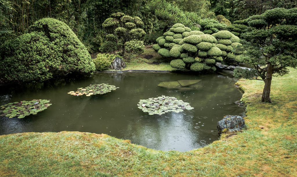
GOLDEN GATE PARK. Golden Gate Park is the largest man-made park in the world with lakes, waterfalls, bridges, lawns, trails, gardens, and public art, all within an area three miles long and a half mile wide. The De Young Museum, located on the Concourse at the intersection of JFK Drive and Hagiwara Tea Garden Drive, showcases the City’s collection of 20th-Century Art, Art of the Americas, Oceanic Art, and African Art, plus special exhibits. Adjacent, the picturesque Japanese Tea Garden is open 8:30am to 6pm; tea served 10:30am to 3pm. 415-752-1171. The Botanical Gardens at Strybing Arboretum is a 70-acre area with over 6000 plant species. Free guided walks daily at 1:30pm. The Conservatory of Flowers, historic Victorian glass house, houses thousands of rare plants. Open Tuesday-Sunday 9am-4:30pm. $5-$3. 415-666-7001. Children’s Playground, off Martin Luther King Jr. Drive, has play areas and a carousel. Rent a rowboat, motorboat, or peddle boat at Stow Lake and take a leisurely cruise. Two Dutch Windmills, dating from 1902, which pumped water to help create the park out of sand dunes, stand at the west end of the park adjacent to the historic Beach Chalet, 1000 Great Highway, with WPA-era murals, a visitor center and restaurants. Order a copy of San Francisco Guide® for a map of Golden Gate Park, points of interest, and transit lines.
HAIGHT ASHBURY. Haight Street, off the east end of Golden Gate Park (between Stanyan and Buena Vista Park), famous for the intersection of Haight & Ashbury Streets, the “Summer of Love (2007 marked the 40th anniversary!),” and hippies, now includes an interesting collection of cafes, vintage clothing stores, nightclubs, and colorful residents.
JAPANTOWN & THE FILLMORE. The City’s Japantown, known as Nihonmachi, covers roughly seven blocks bordered to the north by Bush Street and to the west by Fillmore Street. Japan Center, at Geary & Fillmore Streets, is a complex of buildings with shops selling unique items from the Orient, restaurants, and movie theaters. The Peace Pagoda, pictured, in the plaza is always a photo favorite. Visit www.sfjapantown.org or www.californiajapantown.org for more information.
An adjacent area the locals call The Fillmore offers a smorgasbord of boutique shopping and dining (2000-2200 blocks of Fillmore). At 1805 Geary Street, you’ll find the world famous Fillmore, known for showcasing rock and roll greats. This dance hall turned rock club, still features top acts. 415-346-6000.
LOMBARD STREET. Lombard, the "Crookedest" Street, is neither the crookedest street (that honor would go to Vermont Avenue near 20th Street) nor the steepest in San Francisco-- but it's the best-known. The "crooked" section is the block between Leavenworth and Hyde Streets built with eight hairpin turns on a 40-degree slope. The Powell-Hyde cable car stops at the top of Lombard Street. You can also get there by walking up Hyde (very steep) from Ghirardelli Square, or by walking west from North Beach on Lombard Street.
If you plan on driving down Lombard Street, approach it from Hyde Street. Lombard Street is one-way, and you can't drive up from from Leavenworth. There are pedestrian stairways on either side. Running west from Van Ness through the Marina, Lombard Street becomes the major conduit to Golden Gate Bridge.
THE MARINA. The Marina District is one of the city’s prettiest neighborhoods, with lovely homes and remarkable views of the Bay, Golden Gate Bridge, and the Marin Headlands. Marina Green, a mile-long stretch of green grass running along the edge of the Bay, is a favorite place for jogging, strolling, picnicking, and kite flying. At the west end of Marina Green, explore the Presidio and Fort Point. At the east end, Fort Mason Center, at Marina Boulevard & Buchanan, is a complex of former military warehouses and piers now housing museums, cultural groups, and pavilions for special events. From Marina Green, walk one block south on Baker to the Palace of Fine Arts, pictured. This Greco-Roman structure built in 1915 for the Panama Pacific International Exposition now located on Marina Boulevard at Baker Street, is home to The Exploratorium, called “the best science museum in the world.
MISSION DISTRICT. This area, roughly bordered by Mission, Potrero, Dolores, and Caesar Chavez, owes its name to Mission Dolores, pictured below, the city’s oldest building built by the Spanish Franciscans in 1776. Take a self-guided tour of the Mission, at 16th Street and Dolores, daily 9am - 4pm; 415-621-8203. Mission Street, the main thoroughfare through this vibrant neighborhood, reflects the area’s Mexican and Latino heritage as do the murals on building walls. Call 415-806-0049 (www.jwalks.com) for Mission walking tours; or 415-285-2287 for tours of the local mural art.

NOB HILL & RUSSIAN HILL. To the north of Union Square, at the top of California Street is Nob Hill, the site on which San Francisco's early millionaires Gold Rush and railroad nabobs (slang for wealthy men, which gave Nob Hill its name) built their mansions, now established as some of the city's finest hotels: the Fairmont, the Mark Hopkins and the Huntington. Russian Hill sits to the north of Nob Hill, south of Fisherman's Wharf, west of North Beach. The famous curves of Lombard Street are here. The city's Grace Cathedral, at 1100 California Street, famed for its Ghiberti doors ("The Gates of Paradise"), labyrinths, varied stained glass, and medieval furnishings, as well as its organs and choir has become an international pilgrimage center for church-goer and visitor alike.
NORTH BEACH. Centered along Columbus Avenue just south of Fisherman’s Wharf, North Beach is known for its Italian heritage, as the birthplace of The Beat Generation, and for its restaurants, sidewalk cafes, and nightlife. You won’t turn a corner without enjoying the smell of freshly roasted coffee from local roasteries. Visit the Beat Museum at 540 Broadway with exhibits about the writers, artists, and political activists from “the era that changed the world.” Open Tuesday-Sunday 10am-7pm. Ask about their Literary and Beat Walking Tours. 800-KER-OUAC. www.thebeatmuseum.org. Stop by historical City Lights Booksellers on Columbus Avenue, founded by Lawrence Ferlenghetti, the first all paperback bookstore. The majestic towers of the Church of Saints Peter & Paul overlook Washington Square, at Stockton and Union Streets, a popular park to relax and take in the sights. Two blocks away at 610 Vallejo Street is the Shrine of St. Francis of Assisi Church, dedicated to the city’s namesake. Visit daily 11am-5pm to view historic murals.
PACIFIC OCEAN. The west end of the city ends at the Pacific Ocean. Blustery Ocean Beach the stretch of coast from Lands End to Fort Funston, has flat sandy beaches and paved walkways for strolling, biking and skating. The water is not suitable for swimming, but surfers take advantage of the consistent waves. On a clear day, the sunsets can be spectacular. Enjoy the view over cocktails or a meal at The Cliff House or Beach Chalet, both located on Great Highway. Take Geary Boulevard west all the way to the coast.
THE PRESIDIO. This former military base is now a public park and part of GGNRA (Golden Gate National Recreation Area). Crissy Field, the stretch of shoreline extending from Marina Green to the Golden Gate, features a restored tidal marsh, coastal dunes, a promenade popular with joggers and strollers, and picnic area. Presidio Visitor Center is open daily 9am - 5pm in the Officers' Club, Building 50, on Moraga Avenue near Arguello Boulevard 415-561-4314. The George Lucas Digital Arts Center near the Lombard Gate is surrounded by landscaped greens the public can browse. The Presidio Golf Course near the Arguello Gate is open to the public year-round. A 2.5-mile stretch of the Bay Area Ridge Trail starts next to the Presidio Golf Course Clubhouse.
SOUTH OF MARKET. The area South of Market (SoMa) is a center of art and nightlife with a wide selection of museums, galleries, restaurants, cafes, bars and nightclubs. San Francisco Museum of Modern Art, is located at 151 Third Street. The new Museum of the African Diaspora, tracing man’s roots and culture, is at 685 Mission at 3rd. Visit California Historical Society, 678 Mission Street, the state’s official repository of historical materials, Wed - Sat noon - 4:30pm. 415-357-1848. The Contemporary Jewish Museum, located at 736 Mission Street, presents exhibitions and programs exploring Jewish history, art, and ideas. Call 415-655-7800 for more information. The Moscone Convention Center, bounded by Mission, Folsom, Third and Fourth Streets, hosts an ongoing schedule of conventions. Metreon Center at 4th & Howard, houses movie and IMAX theaters, stores offering the latest entertainment technology, and restaurants. AT&T Park, 3rd and King Streets, is home to the San Francisco Giants. South of Market is a transportation hub with CalTrain Station at 4th & Townsend Streets and Transbay Terminal (Greyhound buses) at Mission & 2nd Streets.
TWIN PEAKS. Follow Market Street southwest (Market turns into Portola) and look for the three masted radio tower atop Twin Peaks which offer sweeping views of the city when not shrouded in fog. To the south of the peaks, Mt. Davidson, the highest point in the city at 938 feet, is topped by a 103-foot concrete cross.

UNION SQUARE. Named for the pro-Union ralleys held during the Civil War, Union Square is the City’s largest shopping area with streets lined with hotels, restaurants, theaters, galleries, department stores and major retailers. The historic park features granite plazas, grassy terraces, and a kiosk where Tix Bay Area sells discount theater tickets. Maiden Lane is a historic 2-block alley extending off Stockton to Grant, now lined with upscale shops, cafes, and salons. Yerba Buena Gardens, the city’s Financial District, and Chinatown are nearby. Catch the Cable Car at Market & Powell for a ride to Fisherman’s Wharf. At the corner of Market & Kearny stands Lotta’s Fountain. Dedicated in 1875, the fountain is celebrated for its role as a message center after the 1906 earthquake. Order a copy of San Francisco Guide® for a map of Union Square with shops, hotels, restaurants, parking garages, points of interest, and transit lines.
UNION STREET & PACIFIC HEIGHTS. Union Street, between Gough and Fillmore Streets, is a popular destination for locals and visitors. This historic area is called Cow Hollow for its origins as dairy meadows. The renovated 19th century Victorians along picturesque Union Street now house upscale shops, restaurants and pubs, businesses and a movie theater. The stately mansions of adjacent Pacific Heights are fine examples of turn of the century Victorians. This area, roughly bordered by Union Street to the north and Bush Street to the south, is home to some of the city’s wealthiest residents as well as foreign consulates. The Haas-Lilienthal House, 2007 Franklin Street, is a landmark Queen Anne Victorian built in the 1880’s. For tours, call 415-252-9485.
YERBA BUENA GARDENS. This urban oasis situated between Third and Fourth, Mission and Folsom Streets features areas of open space, the Martin Luther King, Jr. Memorial and waterfall, the Yerba Buena Center for the Arts with exhibition galleries and theaters, Zeum, (Merit put dynamic link to listing in children’s museums) a hands-on art & technology museum for kids and families; a bowling center, an ice rink, an historic Carousel. For information call 415-820-3550 or visit www.yerbabuenagardens.com.